
The title of this post is a nod to the informative and wonderful blog, LA Creek Freak. My discovery of this blog is fairly recently, if I only I had came across it sooner it might have saved me many hours of informal research. You see, for the past two years and a half I’ve been on a meandering quest to find the paths of old streams that once flowed through our urban areas.
When roaming through the city, I look for tell-tale signs: bridges, dips in the roads, large storm drains, stands of old trees, walls and houses made of river rock and street and neighborhood names with tell-tale monikers i.e. Brookside, Willowbrook, Arroyo Ave, River St, Evergreen, etc. Neighbors and long-time residents are also a great source of information. One of the more exciting clues are the actual streams themselves, they often pop up after heavy rains. The water remembers and will often follow it’s old course. It’s why some places in the city continually flood.
The search has been quite fun. Once I think I’ve found a spot, I’ll take photos, go home and check aerial views on Google maps. I’ll look at the way streets curve or sometimes I’ll notice a line of green trees marking the path of the old waterway. I often read through the Los Angeles Times archives and search for references to streams. For instance, I felt like the area around the Fourth Street Bridge and Lorena was a likely place for a stream and while doing research I found a notice by the city placed in the early 1900s, asking for contractors to bid on constructing a bridge over the “stream running at Fourth St.”
My initial interest in hidden streams was piqued after reading the Bunker Hill, Los Angeles: Reminiscences of Bygone Days book by Leo Politi. In the book he interviews a man who fondly remembers playing in a small pond at the base of Bunker Hill. The stream ran from Echo Park lake into Downtown. For some strange reason, this small bit of information grabbed my imagination and would not let go. The thought of a stream running through such an urban area fascinated me. I grew up in Los Angeles and I just assumed things were the way they were for a reason. As I got older, the history and geography of the city became more interesting. I began to wonder where other streams might have flowed.
Around the same time, I was working in the northern area of Hancock Park in a building that was being plagued with mold and water damage. Dozens of engineers came to assess the situation, each one more baffled than the next at their ineffective remedies. I wondered if perhaps, the water was coming up from underground or if the water table in the area was so high that the water had difficulty draining properly. I checked the library for books on Los Angeles streams and also for historic photos of the Hancock Park area. In many of the old aerial photos I could clearly see the dark, curvy outlines of streams. Finally, one of the engineers said “I think there might be an underground stream causing the damage.” Now that I realized such a thing was possible, I started looking around at my neighborhood and other places for signs of waterways.
I was totally excited when fellow blogger Militant Angeleno did a post on his search for the stream that runs through Hancock Park, Las Jardineras. My favorite article and the way one that really pushed me to continue on my quest was a LA Weekly article with Jessica Hall called The Lost Streams of Los Angeles. I was thrilled to read about someone who was so passionate for the old waterways of Los Angeles. She’s done an amazing amount of fieldwork and research. Through the efforts of LA Creek Freek contributors like Jessica Hall and Joe Linton a map was created marking the historic (and current) waterways and wetlands of Los Angeles. Imagine my joy, when this map confirmed the locations of many of the streams I’d been researching. For a eco-nerd like me, it was quite exciting!
In a series of posts, I’ll be presenting photographs and background information on some of the old stream locations on the Eastside and in other parts of the city. I’d like to inspire others to begin to see the city through the lenses of a new ecology, where the geography of the past and the urban planning of the future can come together more harmoniously.
Hazard Park
The first entry for this series is Hazard Park and the wetlands/stream of this Eastside park. For those of you who do not know, Hazard Park is tucked away behind County USC Medical Center and Bravo Medical High School and is bordered by North Soto St.
In the year 2000, I read an article in the Los Angeles Times about wetland restoration being planned for Hazard Park. I was surprised to discover the park’s watery origins. I would often drive over the little bridge on Charlotte and look over to see the green ditch below and the pretty piece of wild land. I just assumed it was undeveloped. When I read this area was previously wetlands, I began to look at the geography of the area in a different way. It occurred to me the little bridge I drove over was there for a reason, it made me start to think about other small bridges in the city. The bridges are remnants of a time when geography determined development, when we were compelled to give a small amount of respect to what came before us.
History of Hazard Park
Founded in 1884, the park is named for former Los Angeles Mayor Henry Thomas Hazard and was a popular place for outings at the turn of the last century. In the 1970s, it became a well-known Chicano movement gathering spot. Today, the park is home to many recreational activities but has been somewhat crowded in by the looming hospital above it and the architecturally unpleasant high school. The group of homeboys who call this park their home were once a formidable force and their membership continues till today. Something to consider when visiting the park.
There is also a small reservoir that sits on hill above Hazard Park. During the early 1900s, the Hazard Park Improvement Association was one of the most powerful homeowner organizations on the Eastside. The often battled with City Hall, the Los Angeles Water Company and famous Los Angeles water tycoon, William Mulholland. Their biggest complaint? After its construction, the reservoir was ringed by large mounds of earth piled around it which could be viewed from all over the city, sullying the beautiful views of their highland neighborhood. Another grievance, the newly constructed reservoir had been made a “swimming hole for boys and a resort for dangerous men.” Residents demanded fencing and increased patrol of their area.
Some background on the wetlands from the Los Angeles Times:
The 2-acre section, which was once part of a railroad easement through Hazard, has some vegetation that thrives in water, such as cattails, willows and sedges. In addition, researchers have found fresh-water snails and crayfish.
Several years ago, U.S. Fish and Wildlife Service staff members discovered a variety of birds, including the Anna’s hummingbird, the northern mockingbird and the American crow, in Hazard.
“It has a tremendous potential of being developed into a nice wetlands area,” said James Henrickson, a professor of botany at Cal State Los Angeles, who noted that some degradation has occurred in recent years because of neglect and use of the railroad.
Henrickson, Campbell and others are not sure what the parcel’s source of water is. One theory suggests that the old Arroyo de los Pasos, shown on maps drawn in 1894, is the source. Another hints that a section of the old Zanja Madre irrigation system, which was built shortly after the city’s founding in 1781, provides the wetland’s water.
Arroyo de los Posos/Pasos/Pasas
The name of this stream seems to have been interpreted in different ways and I assume they are all the same waterway. It is thought this is the stream that ran through Hazard Park and from my research, I also believe it is. I’ll present more on this stream in my next post.
Photos
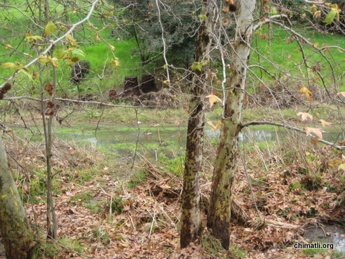
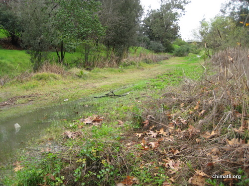
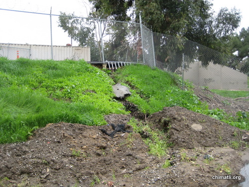
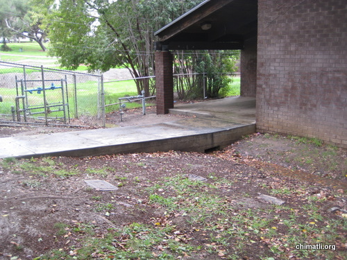
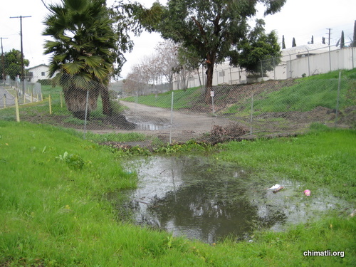
I took these photos last year during the rainy season. I guess there was a fire a few months later and some clueless people cut down all the riparian vegetation that had been growing, just swell, eh?
The above two photos are taken from the bridge on Charlotte. To the left is Bravo High School.
This is looking south from the Charlotte bridge. A small stream of water can be seen in the left hand corner.
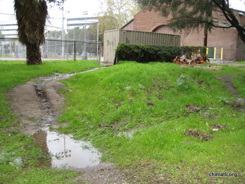
Photo taken behind Bravo High School. The right hand corner shows where a small stream of water is joining the larger flow.
Examples of where water collects in small pools:
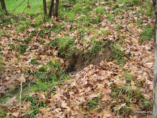
The following photos show various entrances for the water into the larger stream:
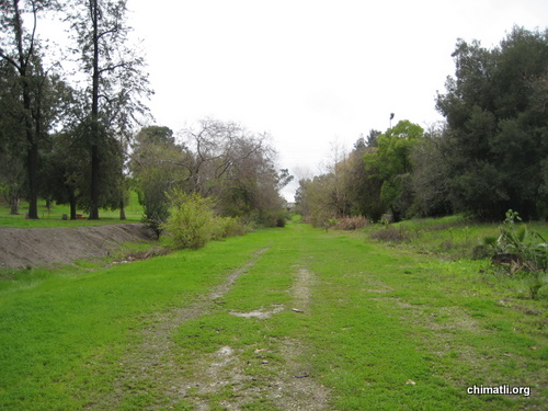
A look “downstream”
The end of the park area, looking north, upstream. All that non-native lush, green grass is not part of a riparian ecosystem.
More info and links on Hazard Park
The Hazard Park Advisory Board (213) 485-6839
Hazard Park Area Wetlands ‘Weed Whacked,’ Says Activist by EGP News
Stream Restoration Planned at Hazard Park By Joe Linton
Activists Maintain Guard Over Eastside’s Hazard Park from Los Angeles Times
Next up: Arroyo de los Posos and why our city forefathers found our Eastside waterways to be a ‘nuisance.’
Also see: The Zanja Madre by alienation







I apologize, this post is having technical difficulties. I hope to have it fixed by today. You should be able to see a bunch of photos.
Very interesting, always tripped out on stuff similar to this, like mostly the creation of the lakes we see now at a few parks in LA, Echo MacArthur, Ken Malloy,Hollenback ect. I think most are man made, but wasn’t it some run off from a bigger water source? I read about something like that before but not sure.
INteresting you should ask DJ! 🙂 One of the questions I had while researching the streams was if the city park lakes were natural or man-made. I wondered if they had once been natural ponds that were expanded for recreational use.
From what I can tell, most were man-made and originally used as water reservoirs. Most were fed by a the Zanja system that would draw water from the Los Angeles River and the Arroyo Seco (at least on the Eastside). It’s possible some of them were real ponds but I haven’t been able to find the info to prove it.
I know for sure there used to be a natural pond in Arroyo Seco park that was eventually drained and filled in.
Please keep reading the series, I have tons more info just not the time to write it all up but the next post should be ready soon!
I consider Lincoln Park ancestral land but I have come to frequent and enjoy Hazard Park despite having to take a longer walk to get there. My five year old son loves to wander in the very places you took pictures of; it will be great to let him know that a stream once ran through here and I’ll keep an eye out for Anna’s hummingbird. Also, the park became A Chicano Movement meeting place as far back as 1968, when students contemplated their strategies and aired their grievances here after walking out of their respective high schools during the famous “blowouts.” Lastly, I would love to hear some historical background on the lake at Deb’s Park!
Nice post Chimatli! Yes, under the 4th St Bridge there used to be a swimming hole. I had family that lived on 6th between Lorena and Grande Vists (down in the White Fence hole), for many years going back to the thirty’s.
And they all said that before there were so many houses there it used to be a little stream, especially after some rain, and they used to swim in big muddy pond that would form there.
I had a neighbor behind my home in Highland Park, she was in her ninties and had been born in that HP home. She described to me a stream that ran diagonally accross N Figueroa at Roy St, she told me they used to herd goats there in the tall stream grass and that there was even an old wooden bridge accross N Fig.
There is also a pool of water and a kind of stream, fed by artesian springs that surface and feed the pool, this is north of Sycamore Grove Park on the east side of Marmion Way just south of where it makes the curve and becomes Monte Vista St. It is kind of hard to see because of all the large trees but if you venture accross the Gold Line tracks and go down the hill a ways it is really lush. An old timer once told me that the steam locomotives used to stop and fill up with the water from that artesian well.
When I was a little kid there used to be water that sometimes flowed down the hills from a spring above the old soap box derby track above Arroyo Seco Playground at the end of Griffin Ave. You can still see the green area where it would exit halfway up the side of the hill.
And also many years ago (in the sixties) I knew people that would fill up water containers to drink from the natural spring at Ferndell Park (part of Griffith Park), they told me then that the water from that spring was believed to be curative by the original Native Americans and then the Mexicano’s.
I think it is still there but some years back the city forbid drinking from the spring due to pollutants.
One year in Lincoln Hts, I think it was 1955 or 56, there were tremendous rains and N Broadway flooded completely, water rose over the curbs and into all the bars and business’s. A couple of weeks after those floods there was a plague of sapos that came out of the LA River, and especially around Frogtown. The streets were slick with smashed toads and even as far away as Happy Valley millions of sapitos were hopping all over the place. An old white lady (Mrs Upton)who lived up on Thomas St hill and who had the most beautiful gardens with palm Trees and cactus and rows of boysenberrys and all kinds of gorgeous plants, fruits, and vegetables, actually paid me and my friend Dodi Lujan to fill up 5 gallon tin containers with baby frogs.
Mrs Upton gave us five dollars for each full can of sapito’s. We just scooped them up with our hands in the LA River below Downey Playground and carried them by hand all the way up N Broadway, left on Eastlake and then up all those Altura Walk stairs, to her gardens at the top. She had us put handfulls of baby frogs in the plants and trees, she told us that this had occured before in the 1930’s and that the toads would eat all the bugs and insects in her garden.
We felt like rich men with 5 or ten bucks each.
Another bit of information that might or might not be of interest. When I was a young apprentice waterproofer I worked for a company called Associated Roof Co. They got the waterproofing contract for the then (1965), new construction of USC Medical Center. I worked months on waterproofing below grade on the outside concrete walls. The waterproofing took place about 20 or 30 feet below the surface, it was dug out with heavy equiptment and we had an area about 6 or 8 wide to work in, I carried buckets of hot coal tar pitch to where we were coating the outside walls. We used big giant rollers and applied the walls with coal tar pitch, a layer of heavy mesh screen and a top layer of hot coal tar pitch.
I got 50 cents extra and hour for that dangerous ass work, breathing those cancer causing fumes, splashing hot tar on the walls, fastening the mesh to the concrete with concrete nails hammered in by hand.
The underground was so saturated with water from the springs in that area that pumps were used to pump out the water continuously so we could work.
I was told by an engineer that there was so much pressure from the spings and water around the building that the new building would essentially be floating on water.
This is referred to in the waterproofing industry as “hydrostatic pressure” and it can be a tremendous force that will work itself thru sold concrete walls and into the building. This sounds like what was going on at your Hancock Park Office Bldg Chimatli.
But I just wanted to bring to your attention the very wet and aquatic like conditions that are to be found around Hazard Park and the General Hospital.
A little extra story about that waterproofing project at USC Medical Center, my memory was just jarred remembering that dangerous project.
As I said we were working down below grade about 30 feet, in about a 6 ft wide space, and working out of buckets of hot (400 degrees) coal tar pitch.
One day some laborer started hand loading a bunch of iron rebar at the top edge of the hole where we were below working in. This guy was just dropping the rebar on the ground above us and it was caused rocks and dirt to fall down onto us below, and sometimes rocks fell into the buckets of hot tar and it splashed out on us, we could have been seriously burned.
The foreman was an old Pachuco dude named Ernie who had gone to Lincoln High with my father. The first time the guy up top knocked rocks and dirt down on us Ernie yelled up at him “Hey Man we’re working down here below you so be careful”, the guy just gave Ernie a dirty look and didn’t say anything. A few minutes later he came back and dropped the rebar near the edge knocking rocks and dirt on us, Ernie yelled up at him, “Hey Motherfucker! I not going to tell you again man, your knocking rocks and shit down on us”.
A half hour went by and all of a sudden the same guy drops the rebar again and knocked a bunch of rocks and shit down on us.
Ernie yells up at the guy, “Alright Motherfucker, thats it Asshole, stay right there I’m coming up and I’m going to beat the shit out of you”.
Old Chuco Ernie ran up the ladder like a madman and attacked the guy, when the rest of us got to the top Ernie had the guy down on the ground and was stomping him. The guy was yelling for mercy but that old vato was doing a dance on his face.
Finally a bunch of us pulled Ernie off the guy before he killed him, the guy’s face looked like hamburger, the Project Superintendent got there and was going to fire us all but we explained what had happened and the guy with the bloody face got fired.
Ernie was all pumped up and yelled out real loud to everyone around, “Any motherfucker that pulls that kind of shit again will be down the street in the Coroners Office if I get a hold of his ass!
Strangely we never had anymore problems after that.
Good times.
haha Great story Don Q! You had me hanging on every word!
Cool post! I always wondered about that weird little stretch of green road in Hazard. Looking forward to the rest of the series.
Chimatli! Great post – we’d be excited to link to your creek research, or invite you to be a guest blogger if you want! I spent a fair bit of time puzzling over creeks and trying to get them restored in NELA, and had a fair bit of heartache over Hazard Park, so if you have any specific questions about the site, I’d be glad to chime in.
I’ve been meaning to do a post on Arroyo de las Pasas, but if you’re moving fast to do something (I take forever), let me know, I’ve got some info (including photos) on it that I can pass along to you.
Yes, to the reader about a wet patch near the Gold Line and Marmion Way – Arroyo del Cal, aka North Branch of the Arroyo Seco. It flowed out through Sycamore Grove Park. And I don’t know the name of the creek at 4th and Lorena, but I have heard tell (and the topography and old maps appear to confirm it) of a stream near the east side of the Evergreen Cemetery, more or less next to El Mercadito (someone remembered his grandmother describing it), and another one on through the west side of the cemetery (which has a small concrete channel in it today). And I agree, a lot of our lakes were reservoirs, but a number of them were over springs, wetlands, or creeks – dammed up little gullies or canyons, often where two tribs came in. MacArthur, Echo Park, Hollenbeck Park, and Silverlake Res. are variations on that theme.
And then there’s intriguing Eastside streams with names like Arroyo del Portosuelo and Arroyo Rosa Castilla (aka Sheriff’s Range Gulch). So much fun!
Wow, I am so honored you commented on my post, Jessica! I love your work and as I mentioned before, you really inspired me to start looking at the city in a different way.
The map you all did is amazing too. After all that driving around town and investigating, it was so great to look at your map and confirm areas where I felt there might be water. It’s interesting how one can become a human divining rod! 🙂
I’m so glad you answered the question regarding city park lakes. I had a really hard time finding information about these places, thanks so much for filling us in.
I would love to read your piece on Arroyo de los Pasos.
My research is really informal, I mostly read old LA Times articles. I don’t have any background in ecology or any academic training so I’m sure there’s lots of stuff I miss or don’t understand. I was curious if you knew about the name variation for the arroyo? In the Los Angeles Times, it’s written as Arroyo de los Posos and I’ve seen in other places it’s Arroyo de los Pasos, which makes more sense.
Thanks for stopping by the blog, I’m looking forward to reading and hearing more about your research and findings!
I enjoyed reading this post and learning about your research process.
I found your blog via L.A. Creek Freak.
Great post! I am glad to see that LA Creek Freak has helped others pursue the hidden creeks in their neighborhoods – and great to read the stories from commenters, too. Restoring the creek at Hazard Park will be a great project – wonderful that you\’re getting the word out on it.
Speaking about L.A. water sources, where was the infamous “Sleepy Lagoon” of the Zoot Suit era actually located at?
I sat for some meetings that The Friends of Hazard Park held back in early 1999? I use to volunteer at Hazard Park before I settled over at Lincoln Park. I wonder how Alex Man is doing? Even though no one told me about the HP wetlands I knew is was something special. As kids we would play there splashing around and be amazed at the water life when you really look into the water and at the plant life. Nothing you would find in your backyard. The wetlands were always a topic of discussion and Alex was always firm in his continuous fight and preservation of the wetlands. As some of you know me I had a chance to take some souvenirs of the streetcar hardware before it was removed. No, I don’t mean a whole rail….
DQ, thanks as always for the informative and humorous comments. I love reading about your stories growing up in Lincoln Heights. If you don’t write a book yourself, I’m going to collect all your comments and get your memoir going myself. I’ll give you the proceeds of course! 😉 Haha!
“When I was a little kid there used to be water that sometimes flowed down the hills from a spring above the old soap box derby track above Arroyo Seco Playground at the end of Griffin Ave. You can still see the green area where it would exit halfway up the side of the hill.”
Where is this place? I’d like to find it!
Also, I never did find the cave you told me about earlier this year. I love those hills above Griffin. Do you know if they have a name? In the early 1990s we fought off some developers who wanted to build up there. At the time, they referred to the hills as Mt Olympus but that doesn’t seem correct.
@Everyone: Thanks for all your comments and stories! Please keep them coming! I’m working on a few more posts and would love it if folks could ask the old-timers in their neighborhoods about what the geography used to be like. So much lost history in Los Angeles…
Thanks Chimatli, but it’s your great posts that always inspire me to recall those old stories, so thank you.
If you stand on Griffin Ave just past the last parking lot at Arroyo Seco Playground and look up the hill towards the Debs Park Pond (which wasn’t there years ago), between the old sanatarium bldgs, you’ll be able to see tha green vegetation that comes down the hill from the old springs. I think there is a storm drain culvert under Griffin Ave that directs water from the hill into the Arroyo Seco River. At the bottom of the hill near the parking lot there is a bunch of Sycamore Trees that I think were fed by those springs. I remember how good those Sycamore trees smelled in the summer,especially at sundown.
And as for the cave above Griffin Ave below “Flattop”, if you look for the house on Griffin Ave with the wide driveway and the u shaped buildings at the rear, (I think there are two large Jacaranda trees in front), what you are seeing is what used to be the old “Indian Head Water Co.”. Above this bldg you will notice a lot of thick vegetation, we used to call it “the Baby Jungle”. At the top of the Baby Jungle can see a rocky discolored area, bare rock and granite as opposed to the grass and weeds around it. I can see this scarred area from the Pasadena Frwy when I pass. This is the entrance to the old cave, but it was collapsed or filled in many years ago. Inside the cave, which goes back towards flat top quite a long ways, it was very damp, dripping water, and a kind of moss or roots hung down from the roof of the cave. Someone once told me that this cave was used during prohibition to stash liquor by organized crime people, I can’t verify if this is true.
I’m working on a project at Los ALamos National Labs in New Mexico at the moment (if you want to see a very wierd place with a tremendous bad vibe about it visit this creepy place), and I won’t be back in LA until the middle of June, but if you want to I would be willing to personally point out the entrance to the cave for you.
Thanks again Chimatli
PS, Everyone I knew always referred to the hill above Griffin as “Flat top Hill” but since the street and area are referred to “Montecito” by some, then maybe that was the historic name?
Thanks, DQ! I would love to participate in a LA Eastside field trip into the wilds of Lincoln Heights.
Xicano Serg, you’re smart enough to do the research but I’ll let you kick it this one time and I’ll skool ya! I got this info from http://www.sleepylagoon.com: “Sleepy Lagoon” nicknamed after a song popular at the time was a reservoir located at 5500 Slauson, crossstreet Atlantic in the Maywood/City of Commerce area. At this time(1940’s), Chicanos were not allowed to swim at public parks, so they took dips in this reservoir located not too far from the L.A.River. A plastics factory and U.S. government owned property now occupy this site.
Chimatli, anything I write on Arroyo de las Pasas will take a while, seriously, if you’re on a roll let me send you stuff; we can come up with a fair exchange!
The oral histories your post has inspired is exactly the kind of thing I love to see-keeping the memories alive!
I hope Chimatli makes good on the threat to publish a book.
Jessica,
I am quite behind too on my post…I will contact you by email to see where we’re at, maybe a collaboration might be good! 🙂
Thanks again!