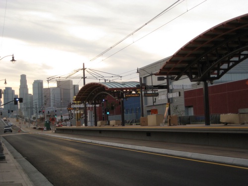
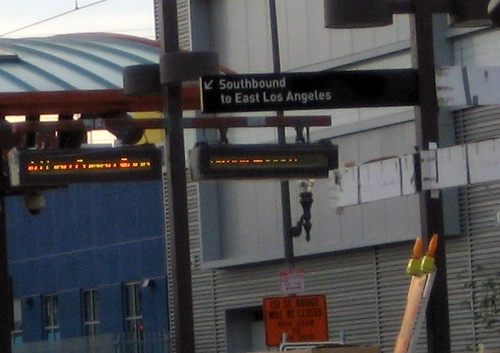
Throughout the line, it seems like the stations are getting closer to completion. You can’t tell from this pic but those info signs at the Pico/Aliso station are lit up and they read “Mariachi Plaza, next stop” or something to that effect.
For some of us, Downtown (aka El Centro) lies west. East of Downtown = the Eastside. Really, not too hard a concept to understand. Unless yer some newbie to the city with a limited sense of geography.
One odd sign I’ve already noticed: the Eastside extension is a Southbound train! I’m sure this makes sense if you consider the part of the Gold line to Pasadena that goes North/South, but “Southbound to East Los Angeles” still seems a bit illogical.
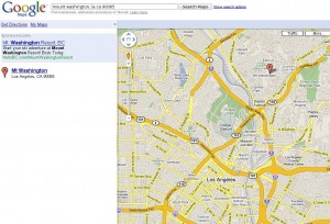
Speaking of lack of logic, check out this google map which places East LA right in the middle of Mt. Washington. (Thanks to reader Graham for pointing this out!)


Ha, Goggle maps are funny! Someone should let the Mount Washington-ites know their neighborhood is considered East LA, they’d get the map fixed right away.
I heard Google uses old train junction names on their maps which is nice and all but irrelevant. Like who knows where Naud Junction is? Sounds like a place where Medusa-like creatures dwell.
Oh and “southbound to East Los Angeles?” Talk about confusing!
Patt Morrison, LA Times columnist/KPCC host, agrees with Google. http://tinyurl.com/dh48qj She lives in Mt. Washington and considers herself an Eastsider. Strictly speaking Mt. Washington is east of the LA River. Is there a north/south division to be considered? I hear people say Northeast Los Angeles. Is that a trivial distinction? If not, where’s the boundary?
great pics.
Im super excited..im glad its ahead of schedule.
I heard that it might open as soon as June 19.
I cant believe its only gonna be a 17 minute commute into downtown from the atlantic blvd station.
– “open,open,open!”
I wish the metro would run 24/7. Then I could go out and party in hollywood, and not have to worry that the Montebello bus isnt running…or that the 30/31 take ’bout an hour and a half after 10pm.
sigh…wishfull thinking i guess.
I heard in NYC the metro runs 24/7, I wish it was like that here. That way I can go out at night & not have to worry about the blue/red line not running.
First thing out of towners like me learn about LA: Outside of Hollywood, everything closes early (except the Ralphs stores in the valley). Not much to keep the trains running late. But the additional train lines are necessary for daytime traffic. It should be a huge help to Eastside residents commuting to downtown.
When I hear “East LA”, I think of Boyle Heights, East LA (unincorporated) and parts of El Sereno, Montebello and City Terrace only. Commerce and Huntington Park throw me for a loop but they feel a little like East LA.
I don’t consider Mt. Washington, Lincoln Heights, Glassel Park or Highland Park “East LA” nor the residents in those areas “Eastsiders.” I would say the East LA area is generally confined between Mission Road and Atlantic Blvd, Valley Blvd and Olympic Blvd.
The Bike Oven in Lincoln Heights/Highland Park refer to their location as being in “NELA” (North East Los Angeles). Calling residents of NELA Northeastsiders weirdly sucks, though.
East LA or East Los Angeles generally refers to the unincorporated area of Los Angeles past Lorena. East Los Angeles has sheriffs and the rest of the Eastside, LAPD.
Lincoln Heights folks are most definitely “Eastsiders,” in fact, LHers are the original Eastsiders as this area was first known as East Los Angeles, then generally referred to as the “Eastside.” Actually, my great aunt who grew up around here said the area around the “Eastside Brewery” near Clover and Main was also called the “Eastside.”
We have a ton of posts up on the subject but here’s one:
http://laeastside.com/2008/09/in-quotes-eastside-stories/
There are real definitions for these places but I know it’s people’s perceptions that usually win out. It’s one of the reasons we started this blog, to help educate.
I think in that section of town as well as many sections of town where people work jobs that don’t shut down (security, maintenance, post office, bouncers, nurses…)that there would be more than enough people to warrant 24 hour service on Los Angeles rails. There used (from what I heard from people who road the bus prior to the rails) to be alot more busses that went 24 hours, but then they cancelled those busses owing to the rails
It must be a generational thing, too. All I’ve known of East LA was going through East LA and BHts since the 80s and seeing these two areas in films like American Me and Mi Familia. I had never really explored LHts or Highland Park or the rest of NELA until recently. It’s interesting to learn that LH was the original East LA. Wow. I was always under the impression that Boyle Heights was the first residential district outside of Downtown/Central Los Angeles when it was officially “founded” in 1875 by Andrew Boyle. Thanks to good old Wikipedia, I’ve learned that “Lincoln Heights is considered to be one of the oldest neighborhoods in Los Angeles, dating back to the 1930s,”.
Well then, bring on the mariachi for the induction ceremony of fellow Eastsiders Pat Morrison and hat collection!
Gee that’s odd Victoria,
” Thanks to good old Wikipedia, I’ve learned that “Lincoln Heights is considered to be one of the oldest neighborhoods in Los Angeles, dating back to the 1930s,â€.
The 1930’s ? Very odd since I have family who have lived in Lincoln Hts going back to the 20’s and the schools and church I attended “Albion St, Sacred Heart, Lincoln High School, are well over 100 years old, let me see now, that would be well before the 30’s.
Wikipedia
History
Lincoln High School was opened in 1878 and moved its temporary quarters to the Avenue 21 School in 1913. Pending the construction of a new school (the current site) on the former mansion property of Charles Woolwine, the Avenue 21 intermediate school moved its location to the hillside site (now the current physical education and track field), where students studied under the trees. [1],[2]
In 1918, the plant was extended across Lincoln Park (Los Angeles) Avenue, which is now the current site. In 1921, the school added a gymnasium and a science building in 1924. The present school was built extensively in the 1930s under President Franklin D. Roosevelt under his Works Progress Administration reform. Much of the construction and renovations occurred after the 1933 Long Beach earthquake, which damaged the gymnasium, the auditorium, the music building, the library, and the English building.
“1830s” says Wikipedia. typo.
Not to get too touchy on the subject but Lincoln Heights and Highland Park are to me, very different neighbohoods. They feel really different culturally. People in Highland Park seem angrier and more aggressive! Hahaha! Just Kidding! 🙂
I guess Lincoln Heights is considered Northeast LA but I spent so much time here as a kid going to all the Chicano events/concerts/happenings with my parents that I always felt like it was part of the larger Boyle Heights neighborhood we lived in at the time. Culturally, Lincoln Heights felt more Chicano, more political. It is afterall the place where the first Walkouts happened. But yeah, I guess some stuff is generational but the lack of information and common knowledge of this part of town’s history is hopefully being rectified by this blog.
ya know what. i think that LHTS should just be Lincoln Heights. dont get us confused with eastsiders. that just a disgrace. LHTS!
one of the comments up there say that LHTS was the original east la. well i guess as the city got bigger the east just got more eastern lol.
but i think that no one in LHTS or East LA would consider LHTS part of east los.
they are two totally different places.
yup Southeast LA forever
Maywood bell cudahy HP south gate, lynwood